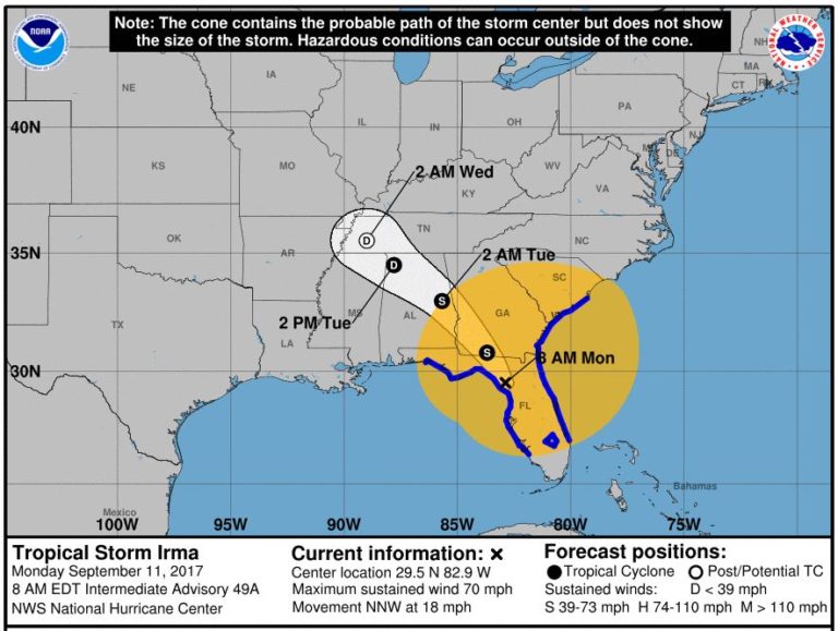
Here is the latest storm track for what has now become Tropical Storm Irma.
The City of Asheville continues to closely monitor the storm for any local impacts. The path of Tropical Storm Irma now appears to be tracking somewhat west of Asheville. It is expected to come through through North Georgia/Tennessee/Western North Carolina on Monday/Tuesday.
The National Weather Service has issued a high wind advisory for the Asheville area from 8 a.m. Monday to 2 a.m. on Tuesday. The forecast also calls for an expected 4 inches of rain in Asheville Monday. For the latest forecast, click here. Here is link to the predicted inland storm track by the National Hurricane Center: Irma storm track.
The latest local forecast from the National Weather Service:
In addition to the wind hazards, locally excessive rainfall and isolated tornadoes will be possible, especially this evening. Winds are expected to be 20 to 30 mph with gusts up to 50 mph. This can blow down limbs, trees and power lines.
On Tuesday, Tropical storm Irma will move away from our area and further weaken over the course of the day, but flash flood and wind threats still will exist in our area through mid-morning.
The City of Asheville has detailed emergency preparedness plans in place, including procedures for monitoring river flow and managing capacity at the North Fork Dam. There was been a gradual release of water at the dam last week to add capacity in case of a major rain event. This is normal procedure.
If floods result from the aftermath of Hurricane Irma, the Asheville Fire Department and Public Works are well equipped for rescue and recovery.
We encourage anyone who lives, works or travels through Asheville to sign up for AVL Alert, the City’s emergency alert notification system.
Within the City, the Asheville Fire Department is the lead agency for emergency response planning and will lead coordination of any emergency response, if needed. Public Works and the Asheville Police Department work quickly to put up barricades on flooded roads or anywhere that waters are swiftly rising.
Motorists are urged to not attempt to drive through flooded areas. Six inches of water will reach the bottom of most passenger cars, causing loss of control. One foot of water will float most vehicles.
On Sept. 6, N.C. Governor Roy Cooper has declared a State of Emergency for all 100 counties as the state prepares for Hurricane Irma aftermath next week.
No emergency response has been activated at this time, though the City is keeping a watchful eye on the storm. For more information, as the storm passes through our area, check the City of Asheville website (scroll down to “latest news.”) Information will also be posted on the City of Asheville Twitter feed and Facebook page.
Emergency preparedness kit
A home emergency preparedness kit is advisable for any time of the year, to include a flashlight and batteries, nonperishable food and a 3-day supply of water. Find tips on items to include in an emergency preparedness kit here.
